|
Compare Web and Desktop Wild Plants
How do you decide which version of
the package is best for you? The information below is designed to
help you make that decision by comparing the basic components of the
packages. You will notice that there is a considerable overlap in
the two so really the most significant question to answer is whether you
prefer a web-based delivery or one on a workstation.
A web-based package will be available to
you on any computer, regardless of its operating system, provided it is
connected to broadband. It will also be regularly updated and
refined so that you always have the most up-to-date version. The user
needs a username-password combination (which we supply) for access.
A desktop package, which is supplied on a
USB Flash Drive, does not require any
access to the Web so it is independent of broadband connections and is
completely portable (can be installed on any suitable computer).
The USB package will generally
display photographs more rapidly than the web version (more
or less instantaneous display versus 1 second or so on the web).
| Feature |
Web
Version |
Desktop
Version |
| Distribution data |
1 x 1 minute grid |
1 x 1 minute grid |
| Distribution map scale |
1:1,000,000 |
1:1,000,000 |
| Search map scale |
1:250,000 |
1:250,000 |
| Map output options |
Vector maps in PDF |
Vector maps in Windows
Metafile |
| Species list output
options |
PDF and CSV |
RTF and CSV |
| Photograph display |
Scaled to fit screen |
Scaled
to fit screen |
| Photograph output |
PDF file and printer |
Only an option as part of the picture, text and map. |
| Picture, Text and Map
output |
PDF file and printer |
Printer |
| Operating environment |
Windows, Mac, Linux
with a variety of browsers. Needs broadband. |
Microsoft Windows XP,
Vista, 7, 8 |
| Access to package |
Any computer with
broadband. requires username and password for each access. |
Any computer on which
the package has been installed and which has the USB Flash Drive
attached. Package is hardware-locked to the USB device and
requires a device key to run. |
| Updates |
Continuous as
information and software become available |
1-2 years. |
| Payment |
Annual subscription |
Two-year
subscription |
|
|
Web Version |
Desktop Version |
 |
 |
| Grids plotted on a simple map with
basic roads and some towns. Grid colour represents date of
most recent record. Map can be exported as a PDF or sent to
a printer, |
Grids plotted on a simple outline of
Victoria. Grid colour represents date of most recent record.
Map can be exported as a Windows Metafile or sent to a printer, |
 |
 |
| Grids plotted on a higher resolution map with
more roads, river, mountain and town names. Grids are
hatched. Map can be exported as a PDF or sent to
a printer, |
Grids plotted on a
higher resolution map with
more roads, river, mountain and town names. Grids are
hatched. Map can be exported as a Windows Metafile or sent to a printer, |
 |
 |
| Individual pictures can be
displayed. Images are intelligently resized to fit the
screen. Image can be printed. |
Individual pictures can be displayed.
Images are intelligently resized to fit screen. No export but
can be printed as part of combined picture, text and map (see
below).. |
 |
 |
| A combined picture, text and map
can be displayed. This can be printed or exported as a PDF
file. Map is a simple outline with red grids. |
A combined
picture, text and map can be displayed and printed. Map shows
some feature. No export
option unless user has a PDF printer driver.. |
 |
 |
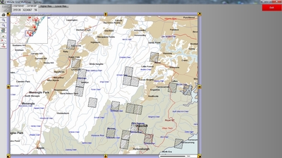
| A high resolution map
showing parks and other forms of land use is the
basis for searching an area for species. |
A high resolution map
showing parks and other forms of land use is the
basis for searching an area for species. |
 |
 |
A species list is generated from the
grid search. This list can be exported as a CSV file (comma
separated values - suitable for spreadsheets) or a PDF file.
The list can be filtered on a range of categories which are
available through drop-down lists on the web page.
Small pictures and text are displayed as each name is highlighted.
Larger pictures, distribution maps or picture-text-map combinations
can be displayed with a single mouse click. |
A species list is generated from the
grid search. This list can be exported as a CSV file (comma
separated values - suitable for spreadsheets) or a Rich Text (word
processing) file. The list can be filtered on a range of
categories which are available through a filter routine.
Small pictures and text are displayed as each name is highlighted.
Larger pictures, distribution maps or picture-text-map combinations
can be displayed with a single mouse click. |
|
