Wild Things of Victoria 
Web versions run with IE, Firefox, Opera, Chrome and Safari Distribution Maps  Desktop versions run on USB Flash Drives with Windows 8, 7, Vista and XP
Viridans Home Flora Fauna DB Home Picture Text and Map Species Distribution Searches Tutorials

Maps at a Range of Scales
The distribution of any species can be plotted simply on a map of Victoria with the land use theme (national parks, conservation reserves, wilderness areas, public and private land) at a number of scales from 1:1,000,000 to 1:100,000.

You should first select the species you are interested in and with a single mouse click you may display a map of Victoria with its full distribution.  You may then increase the resolution of the map to show more detail.

Any of the maps can be printed or exported as full vector graphics (in PDF format on the web-based versions and Windows Metafiles in the desktop version).

The examples below are all taken from the desktop version of Just-a-Minute Animals but the same results (with minor variations) can be obtained from the web version.

 
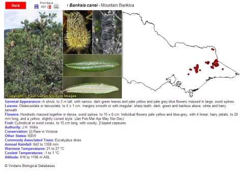
Select a Species
After which you can display a summarised photograph, description and simple state-wide map
Plot Low Resolution Map
The 1:1,000,000 map of Victoria will give you a clear overview of where the species is found across the state.  This is a true vector map and any portion can be magnified.
Banksia canei Low Resolution Map
Plot Medium Resolution Map
The 1:250,000 map tiles will give you a
more detailed look at regional distribution.  Each of these map tiles overlaps by 50% with its neighbours.
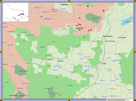
Plot High Resolution Map
The 1:100,000 map tiles will give you the best view of the data at a local level.  Like the other maps these map tile can be magnified and
each overlaps with its neighbours.
Medium Resolution Map High Resolution Map